History
Historical and Regional Overview
 This chapter is intended to give an overview of the significant events and development patterns, both local and regional, that have had an impact on the Town of Amsterdam. Understanding and interpreting these past events and regional influences is very important for a community comprehensively planning for it’s future.
The information contained in this chapter was arrived at by researching a number of documents related to the early history of New York State, Montgomery County and the Town of Amsterdam (please see bibliography). Further assistance and insight was provided by the Montgomery County Department of History and Archives.
As previously mentioned, this chapter is only intended to provide an overview. Additional historical and cultural resource inventory and analysis is included in Chapter 3: Socio-Economic Resources.
Historical Outline
Town of Amsterdam
1710: Sparse and temporary early settlement by German Palatines.
1716: Philip Groat, of Rotterdam (Holland) acquired the title, direct from the Mohawk Iroquois, to a strip of land in the eastern part of the town.
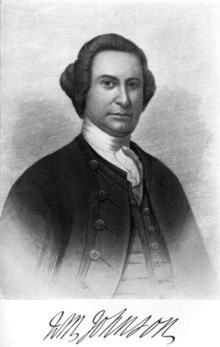 Sir William Johnson 1740 Sir William Johnson built a homestead in the town, near the present day western end of the city.
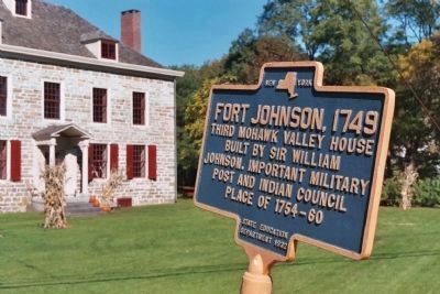
1742: Sir William Johnson built and moved into Fort Johnson on the Kayaderosseras creek.
1755: Mrs. Eva Van Alstyne was wounded and scalped by Indians, while crossing the stream near Cranesville. The stream now bears the name Eva’s Kil creek.
1772: Tryon County formed, which included the Mohawk District, the lands north and south of the river from the Hoffmans rock cut to “The Noses” near Sprakers and Palatine.
1777: Joseph Hagaman founded the settlement of Hagaman’s Mills.
1778: Mohawk District realigned, all land north of the river designated as Caughnawaga.
1793: Caughnawaga was divided into four towns: Johnstown, Mayfield, Broadalbin and Amsterdam.
1794: First Town Board on record.
1804: David Crane operated a hotel along Mohawk Turnpike, in the hamlet now known as Cranesville.
1810: Town population of 3,039 in U.S. census.
1838: Fulton County formed from Montgomery County, the Town of Perth separated from the Town of Amsterdam.
1857: The “Star Hosiery Mills” were established in Hagaman.
1880: Town population (including the City of Amsterdam) of 11,710 in U.S. census.
1870s: “Hurricana Farms” thoroughbred racing stables established by Stephen Sanford.
1885: City of Amsterdam incorporated and divided out of the Town.
1890: Town population of 2,948 in U.S. census.
1940’s: First major apartment complex completed (Northampton Court).
1960’s: Several major industries relocate from the City to the Town of Amsterdam, including Amsterdam Printing Company and Mohawk Finishing Products. The Earl Matthewson Farm was subdivided to create residential properties on Country Ridge Drive.
1963: The Stephen Collins farm of 140 acres was developed into the Big N Shopping Center. Amsterdam Memorial Hospital relocates over the City line to Route 30.
1964: Town prepares Master Plan and adopts Subdivision Regulations.
1968: Part of the Matthewson Farm was developed into the Family Bargain Center.
1972: Town adopts Zoning Ordinance. Greater Amsterdam School District opens Tecler Elementary School on Northern Boulevard.
1973: New Town Hall containing Town offices dedicated on Manny Corners Road.
1977: Two new County roads are constructed: Miami Avenue connecting Midline Road to Route 30, and Maple Avenue extension connecting the Village of Hagaman to Route 30. Greater Amsterdam School District opens the new Amsterdam High School on Miami Avenue in the Town.
1990: Town population of 5,962 in U.S. census. Commercial development continues along the Route 30 corridor.
1993: Big box retail giants Wal-Mart and Super K-Mart open new stores opposite each other along NYS RT. 30.
1994: Town adopts Site Plan Review Regulations.
Late Commercial development continues along
1990s: Route 30, including Kem Plaza, Sanford Farms and Town Square Shopping Centers. Former Kmart and Price Chopper Plazas redeveloped for commercial use. Super K-Mart and Office Max close. Discussions begin with Home Depot to locate in Hannaford Plaza.
2000: Town population of 5,820 in U.S. Census. Town works with the City of Amsterdam and DEC to extend water service along the Route 30 corridor to serve new develop-ment. Plans begin to reuse former Hurricana Farm barn as a cultural center and museum.
2001: Home Depot opens in Hannaford Plaza.
2002: Town signs 40-year water contract with City. Ruby Tuesday opens in Hannaford Plaza.
Historical Background and Development Patterns
The most modern pre-European inhabitants of the area that is now called the Town of Amsterdam were the Native Americans, referred to as the Mohawks. The Mohawks were a member of what the British called the “Five Nations”, or the French called the “Iroquois Nation”. This nation began as a confederation of five eastern woodland Native American tribes. The other tribes of this nation were the Oneidas, Onondogas, Cayugas and Senecas. The Mohawks were the most eastern tribe, and controlled the area from present day Albany westward to the Susquehanna and Delaware Rivers, and as far north as the St. Lawrence River. The Mohawks and other tribes would come to play a legitimate role in the settlement of the area, and later during the American war for independence.
European settlements in the Town supposedly commenced as early as 1710. Little information is available, but the earliest pioneers are thought to be German Palatines sent here under the patronage of Queen Anne of England. At the same time Holland Dutch settlers also moved up the Mohawk Valley from Schenectady and other parts.
The earliest patent was issued to Geraldus Camfort on April 22, 1703. The title was to twenty acres of land lying within the present day town of Amsterdam. This is thought to be the first patent granted by the English Colonial Government within the present limits of Montgomery County. The Chatsandackte patent was granted to Ebenezer Wilson and John Abeel on February 22, 1706. This also was within the town. However no evidence exists that any of these early title holders or their representatives settled their lands.
The earliest known family to settle within the Town was that of Philip Groat. Groat, of Rotterdam (Holland), acquired the title, direct from the Mohawks, to a strip of land near present day Cranesville. This is probably the earliest grant obtained from the Mohawks. The Mohawks conveyed “all the land between the creeks (about one mile, embracing Cranesville), as far north from the river as the grantee may desire.” Philip Groat never settled his land, but was drowned in the Mohawk, near Schenectady, by breaking through the ice in a sleigh. He was in route to his new land. His widow, three sons, and several domestics, made the intended settlement. The first grist mill on the north side of the Mohawk river was erected in 1730 by the Groat brothers, at what is now Cranesville. The mill, for a time, served the settlement of German Flats some fifty miles up river.
An interesting side note of Groat family history surrounds the youngest of the three brothers, Lewis. In the summer of 1755, Lewis Groat was taken prisoner by three hostile Native Americans belonging to the Owenagunga tribe. He was taken to their homeland in Canada, where he was forced to run the gauntlet, a ritualistic combat challenge. He was later sold to a French Canadian, named Louis de Snow. He remained his servant until the declaration of war between Great Britain and France. He was then claimed as a British prisoner, and sent to St. Francis Way, near Montreal. He remained imprisoned there for six months. Finally he was liberated, and returned home after an absence of four years and four months.
This was apparently a dangerous time in the Town. In 1755, while on her way from Johnstown to Schenectady, Mrs. Eva Van Alstyne was wounded and scalped near present day Cranesville. The attack took place at a stream which now bears the name Eva’s Kil creek.
This hostility and subsequent delay in early settlement was in part due to the ill-famed Kayaderosseras patent. A 1704 land swindle that infuriated the Mohawks when they discovered that the “big enough for a farm” tract of land they had conveyed was actually about 700,000 acres lying between the Mohawk and Hudson rivers. Over fifty years passed before the Mohawks were compensated, and then only partially.
In 1738 Sir William Johnson built the first of his many homesteads in the Mohawk Valley at Warrensbush, in the present day Town of Florida. Warrensbush was his uncle’s holdings, and Sir William, at the age of 23, was sent to manage his affairs. He later moved to a site near the present day City and Town of Amsterdam boundary along the Mohawk River. In 1742 he again moved to a site about two miles further west on the Kayaderosseras Creek, on land he had purchased. In 1744 he built a flouring mill and stone mansion, calling his new estate Fort Johnson.
Sir William played an important role in the early settlement of the Mohawk Valley. His influence over the Native American tribes led to his position as “Chief of Indian Affairs” for the British government. His knowledge of their customs and language led to the Mohawks giving him the honorary rank of chief. During the French and Indian War he attained the rank of major-general in the Provincial forces. He and his family remained loyal to the British government throughout the later half of the 18th century, in particular during the Revolution.
Following the closure of the Revolution and its associated hostilities, settlement around the Town began to flourish. By the end of the 18th century a number of farm settlements were located throughout the Town. Around 1797, the first schoolhouse was erected on “Olmstead Hill,” at the intersection of present day Route 67 and Jones Road. The first religious organization was formed in 1792 in connection with the Dutch Reformed Church. Meetings were held in barns, groves or dwellings until 1800, when a church building was constructed at Manny Corners. This Church was the forerunner of the present day United Presbyterian Church of Amsterdam and the Calvary Reformed Church in Hagaman.
After the Revolution the need arose for improved transportation systems. As early as 1790, stage coach service was provided from Albany to Johnstown and Canajoharie. The Mohawk Turnpike Company was incorporated in 1800 and a road was built between Schenectady and Utica. In 1804, David Crane operated a hotel along the Turnpike, in the hamlet now known as Cranesville. In 1825, the Erie Canal was completed, increasing trade, commerce and settlement in the region. The first railroad connecting Amsterdam with distant points opened in 1836. Improvements have been made to all transportation systems over the years, greatly enhancing the accessibility of the Town and its environs.
The Town of Amsterdam had several areas which developed into villages and hamlets. Until its charter as a city in 1885, the Village of Amsterdam was the largest village in the Town. Well over half of the Town residents at the time lived in the Village of Amsterdam. The original settler of the “village” was Aaron Vedder, who established a saw-mill and grist-mill near the mouth of the North Chuctanunda creek. The mouth of this stream is nearly opposite a matching stream on the south shore of the Mohawk, and they were both named from the Native American word for “twin sisters.”
In 1813, the “village” was described in one writing: “On the Mohawk turnpike, near the mouth of the Chuctanunda creek, is a small collection of houses called Amsterdam or Veddersburg, where is a post-office, a Presbyterian church, a school-house, 25 dwellings and some stores, mechanics’ shops, mills, etc.,” with a population which did not exceed 150.
Close to the time Aaron Vedder arrived at the mouth of the North Chuctanunda, Joseph Hagaman settled on land further up stream that would one day become the Village of Hagaman. This was the northern most settlement in the Town at this time. In fact, the only road north of Manny Corners was an opening cut through the forest just wide enough to allow the passage of a wagon. Following the lead of Joseph Hagaman and Aaron Vedder, a number of mills were established in the area. In 1802, it was reported that five mills were along the North Chuctanunda (this included West Galway, which at the time was part of the Town). In 1813 it was reported that along the same stream there were established: 5 grain mills, 4 saw mills, 2 carding and 2 fulling machines used to manufacture wool cloth, 2 oil mills, a trip hammer, and an extensive iron manufacture. The hamlet of Hagaman Mills incorporated as the Village of Hagaman in 1892.
The area near the mouth of the Kayaderosseras creek was originally settled by Sir William Johnson. By the latter part of the 19th century the area was known as Akin, named after the Ethan Akin family who owned much of the land in the area. In 1903 the hamlet of Akin incorporated and officially designated its name the Village of Fort Johnson.
Cranesville and Tribes Hill were, and still are today, important hamlet areas of the Town. Both developed along transportation lines and were important areas of commerce for residents of the area. Today the hamlets are primarily residential communities. Cranesville is situated on the north bank of the Mohawk, about three miles east of the City of Amsterdam. It was named in honor of David Crane, who settled there in 1804, and kept a hotel for many years. It contained a small station of the New York Central Railroad, a church, store, saw mill, post office, and cluster of homes. Tribes Hill is a hamlet located partially in the western section of the Town of Amsterdam, and partially in the Town of Mohawk. Its name came from the tradition of Native American tribes assembling at this prominent point overlooking the Mohawk River. A suspension bridge was built in 1853 spanning the Mohawk River and connecting Tribes Hill to Fort Hunter. By the late 1800s the hamlet contained a post-office, two churches, a store, school house, shops, and a railroad station.
The Town has continued to grow both as a residential community and as the area’s commercial center. In the early 1960’s the first shopping center developments were built along Rt. 30 North. Today the Rt. 30 corridor in the Town is referred to as “the miracle mile.” Since the opening of the new Big Box retail stores (Wal-Mart and Super K-Mart) in 1993, the Town has seen a rapid increase in development proposals along the corridor. Square footage of commercial space doubled along the Route 30 corridor from 1990 to 2000. Route 67 has also experienced a moderate increase in development. The Town reviews each new development proposal, hopefully ensuring that any impact will be mitigated to the extent practical.
Residential development is also on the rise in the Town, with approximately 6 new housing starts per year. The Town’s regional location, low taxes, rural character, and other amenities have encouraged new residential development.